We head 400km north-west of Brisbane and then 900m skyward to find a WW2 crash site that’s not to be missed
Where can you combine exploring a ridgy-didge full-on WW2 bomber crash site, maxed out suspension stretching 4WDing, bush camping beside a bubbling creek and magnificent panoramic views from the top of some tablelands? Buckle up the seatbelts and enjoy all that and more at magnificent Kroombit Tops National Park.
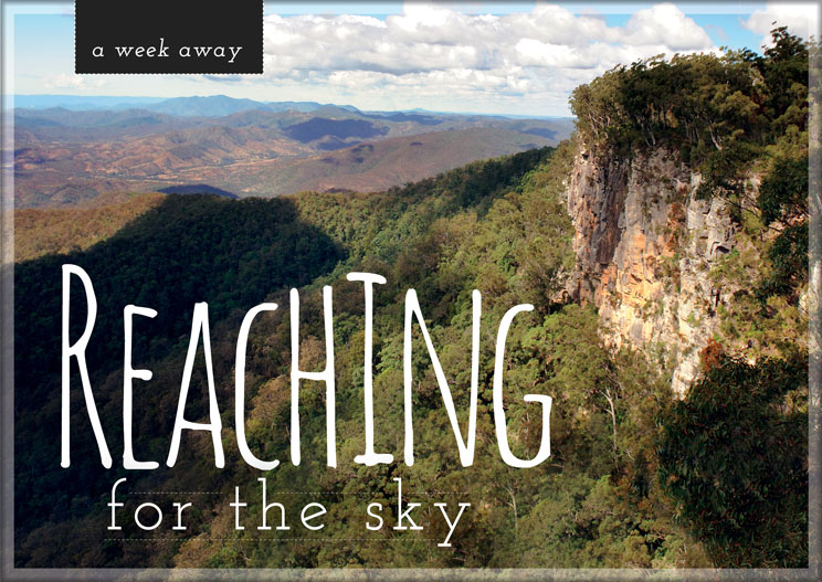
Situated in the Boyne Valley in central Queensland, Kroombits is a stunning hinterland with sweeping gorges, fantastic landscapes and incredible 800 metre high sandstone cliffs which seem to rise into the clouds on approach and are then capped by a magnificent plateau of sub-tropical eucalypt forest. It erupts to roughly 930m at Amy’s Peak and reaches 940m on the ridge between the Kroombit and Dry Creek valleys. With such steep and rugged terrain you would expect plenty of creeks – and there are, as Kroombit, Dry and Callide Creeks flow westward into the Fitzroy River and Munholme and Three Moon Creeks flow to the south into the Burnett River via Cania Dam.
The area around Kroombit Tops was originally taken up for sheep grazing between 1854 and 1860 but it is likely that the Tops were not explored by Europeans until the discovery of gold in the surrounding area in the 1870s and 1880s.
The trip in can be made by conventional vehicle from Ubobo in dry weather – but really a high-clearance 4WD is required, especially once inside the Park or if things get a bit wet. The main tracks from Ubobo and Monto wind through magnificent farming valleys with running streams and cattle lazily grazing amongst the gums. At one point the track follows a ridge and splits an old Queenslander homestead from the property’s sheds, giving a special insight to country life.
Shortly the nose of the truck starts to look skyward as the steep climb up the side of the range begins (about 2nd gear steep for the Defender). The howling turbo gets a bit of rest once inside the Park at the Barracks, an old forestry camp established in the 1960s. The access road was built from the northern side between 1964 and 1968 to allow logging which continued from 1969 to 1995 with open forests of Sydney Blue Gum (a particular favourite of the axemen) on the eastern lower slopes and broad valley floors.
There are three camping areas with Griffiths Creek being the main one… and what a scorcher it is. Flat, lush green-grassed campsites abound amongst magnificent big gums with ample room for big and small camps. Plenty of room to dob a Sherrin end to end (no problem) or go ‘taddying’, as Griffiths Creek splits the campground.
The Parks map blandly shows one of the features as a ‘Bomber Crash Site’ and having been to crash sites where a few bits of rusted steel are all that remains, the expectation bar was set pretty low. To be honest we were more excited about the track in – the 4WD Loop Road – which after very heavy wind and rain a week or so earlier was throwing up plenty of challenges in the form of downed trees, erosion and muddy stretches.
However what awaits is the spectacularly amazing final resting place of ‘Beautiful Betsy’ – a WW2 United States Army Air Force B-24D Liberator bomber. Betsy crashed in 1945 on a return flight from Darwin to Brisbane with the loss of eight lives (six American aviators and two Royal Air Force Spitfire pilots). Named after the wife of the original pilot, Betsy’s first combat mission was a flight over enemy-held Timor Island in 1943 and she flew another 25 missions before being retired from combat as a result of stress resulting from flying in bad weather and a heavy landing.
Amazingly, despite extensive searches, the crash site remained a tragic mystery for 49 years until Park Ranger Mark Roe found it after a controlled burn-off in 1994. Theory has it that the plane was in a shallow descent during crook weather just before crashing. The force of the impact can still be seen from the bent and twisted pieces of wreckage strewn across the hill with the four 14-cylinder Pratt and Whitney R-1839-43 twin wasp radial engines (each rated at 1,2200hp) being hurled some 100 metres. The very distinctive tail section is still largely intact whilst one bent propeller lies idly by.
Being aluminium, the wreckage looks just like it was when found – with pieces laying randomly across the hillside… it is just amazing. A tragic side story was that Flying Officer Roy Cameron was due to be married to his fiancé Daphne in Brisbane four days later, and one of the other men killed was to have been his best man. The site is now preserved as a monument to the tragedy. Out of respect, please leave it as you have found it. But don’t miss it – it’s an absolute beauty.
Betsy is part of the 35km Loop Road which is worth locking the hubs in for, on its own account. Drivers are advised to have some
off-road driving under the belts and a high-clearance vehicle – and that would be pretty good advice in this rugged terrain, especially on the one-way section. The drive also encompasses ‘The Wall’ which is a top stop to spend the night or pause for a cuppa.
Without doubt though, the big Kahuna is the 27km one-way Razorback Track where the stubby lever will be firmly engaged and all the low number gears will be used. The track was cut in 2014 to allow access to the Park from Biloela through Lochenbar Station via a prescribed 4WD public roadway. Wouldn’t we like to see a lot more of that! This is not for the inexperienced, camper trailers or all-wheel drive vehicles and will take about two hours one way with numerous creek crossings, steep uphills and some almost ‘standing in the footwell’ downhills. Rain the week before left some muddy sections and a bit of residual flow in the creeks just to add some extra interest – but it is easy to see why it is nominated as a dry weather only track. Apart from the wheel lifting, suspension maxing thrills, the scenery is magnificent with sweeping panoramic views as the track follows narrow twisting ridges. The Razorback Track is well named and a ‘must-do’.
For those who enjoy stretching the calf muscles, there are several excellent walking tracks. A short 100m stroll to the Lookout is rewarded with spectacular views of the surrounding ranges and valleys; ranging up to the Escarpment Track which is 13km one way. Sadly we strained our hammies in the car park and will have to save that one for ‘Ron’.
Whilst not the easiest Park to get to, Kroombits is certainly one of the very best with visitors rewarded in spades for the effort taken. It is breathtaking in every aspect from the fabulous camping to amazing Betsy to the exciting Razorback Track.
Without doubt Kroombits is the National Park equivalent of Roy and HG’s saying: “When too much sport is never enough!”
Destination Details
Where:
400km north-west of Brisbane in the Gladstone, Monto, Biloela triangle.
How to get there:
85km south-west of Gladstone via Calliope, 66km north of Monto, 70km west of Ubobo; all best in 4WDs.
Access from Biloela via the Razorback Track is most definitely for experienced 4WD; no camper trailers or all-wheel drive vehicles.
Detailed directions are on the QPWS web page:
https://www.nprsr.qld.gov.au/parks/kroombit-tops/
Camping:
Bush camping at Griffiths Creek and Razorback camping areas, as well as The Wall.
Use existing campfires and bring your own wood. Collecting firewood is prohibited so don’t be responsible for stealing a white ants’ home.
You need to be self sufficient in the bush zones as no facilities are provided. Toilets are available at The Lookout.
Camping fees of $6.15 per person per night or $24.50 per family per night apply. Sites can be booked online at:
https://qpws.usedirect.com/QPWS
Supplies and facilities:
Best to be as self-sufficient as possible because nearest supplies are at Biloela and Gladstone.
Trip standard:
Degree of difficulty for most of the Park is easy, but the one-way section of the Loop Road and the Razorback Track require off-road driving experience. Not routes to cut your teeth on if alone.
Maps and guides:
The download map on the QPWS website is pretty good; it’s all you should need when in the Park:
https://www.nprsr.qld.gov.au/parks/kroombit-tops/pdf/kroombit-tops-map.pdf
A handy tip if you run Oz Explorer is to set your campsite as a waypoint as it makes it much easier to find it again when returning from your day’s adventure.

